Mosi-oa-Tunya / Victoria Falls

These are among the most spectacular waterfalls in the world. The Zambezi River, which is more than 2 km wide at this point, plunges noisily down a series of basalt gorges and raises an iridescent mist that can be seen more than 20 km away.


This slideshow requires JavaScript.

The Mosi-oa-Tunya/Victoria Falls is the world’s greatest sheet of falling water and significant worldwide for its exceptional geological and geomorphological features and active land formation processes with outstanding beauty attributed to the falls i.e. the spray, mist and rainbows. This transboundary property extends over 6860 ha and comprises 3779 ha of the Mosi-oa-Tunya National Park (Zambia), 2340 ha of Victoria Falls National Park (Zimbabwe), 741 ha of the riverine strip of Zambezi National Park (Zimbabwe). A riverine strip of the Zambezi National Park extending 9 km west along the right bank of the Zambezi and islands in the river are all within the Park as far as Palm and Kandahar Islands, with the Victoria Falls being one of the major attractions. The waterfall stands at an altitude of about 915 m above mean sea level (a.m.s.l.) and spans to about 1708 m wide with an average depth of 100 m and the deepest point being 108 m. Sprays from this giant waterfall can be seen from a distance of 30 km from the Lusaka road, Zambia and 50 km from Bulawayo road, Zimbabwe. Basalts have been cut by a river system producing a series of eightspectacular gorges that serve as breeding sites for four species of endangered birds. The basalts of the Victoria Falls World Heritage property are layered unlike those of the Giants Causeway World Heritage site which are vertical and columnar.


Find more at http://goo.gl/LFLsIO


PRSKALO WATERFALL

Prskalo waterfall is one of the most beautiful and most interesting waterfalls in Serbia, with its very unusual structure that resembles a tall stone sculpture. The water from the nearby spring flows over the top of the rock, creating a thin but powerful jet. It is located in the Kučaj mountains, 17 km away from the nearest paved road, at about 760 meters above sea level. Continue reading

Mount Roraima

Today we will talk about Mount Roraima, one of the oldest mountain formations on Earth, a natural border between Venezuela, Brazil and Guyana in South America. It is also called Roraima Tepui or Cerro Roraima.

There are some wonderful places on Earth that offer such breathtaking views that they might just stick with you forever and ever down in some rusty memory box. And there are others worth discovering that we do not even know about.

This site is about unconventional traveling ideas, a place where people can find unworldly landscapes and a new way of seeing things. And this is definitely one of them.

mount roraima

Long before the European conquistadors took over these lands, Mount Roraima was considered a symbol of these regions, an “axis mundi”, an enormous tree within which all the vegetables and fruits of the world grow.

This mountain, surrounded by 400 meter (1,300 ft) tall cliffs was a place of mystery, myths and legends for the indigenous people that used to live here centuries ago.

amazing roraima mountain

Today this unusual looking mountain can be visited by anyone having the will to discover it. The ascend starts in the Pemón village of Paraitepui which can be reached via the town of Santa Elena.

Getting to Mount Roraima is possible by taking a plane to Santa Elena de Uairén airport. This is a town in Brazil, very close to the border.  From here on, you will see there are buses or shuttles that can get you close to the ascending point- the village of Paraitepui.

Hiking here is not hard and you can also get help from the indigenous population, as they organize tour guides in exchange for a small sum of money. If you are on your own however, try to reserve at least four days for this fantastic journey, as there are plenty of things to see and enjoy up there. Mount Roraima is said to have some of the most fascinating hiking trails in the world

You should not leave after 2 p.m. from the village as trekkers are no longer allowed after this hour. At the beginning of your climb, your baggages will be strictly checked and you can not take more than 15 kilos with you. So careful how you organize things. Being given that this is a national park , you are not permitted to take rocks or plants along the way.

The top of the mountain measures 2,772 m, it offers amazing landscapes and establishing a tent around here is possible. However, you should know the weather changes suddenly in this area so be prepared.

This slideshow requires JavaScript.

You can find a complete tour guide to hiking Mount Roraima here.


Whitehaven Beach

Whitehaven Beach is a 7 km stretch along Whitsunday Island, Australia. The island is accessible by boat from the mainland tourist ports ofAirlie Beach and Shute Harbour, as well as Hamilton Island. It lies across from Chalkies Beach on Haslewood Island.

Whitehaven Beach is a pristine, award winning beach on Whitsunday Island, the largest of the 74 islands in the Whitsundays. Whitehaven Beach stretches over seven kilometres and boasts brilliant white silica sand that is among the purest in the world. Sink your feet into the sand and wade into the warm waves that gently lap the shore and you’ll soon realise why people come here from all over the world.

At the northern end of Whitehaven Beach is Hill Inlet, a stunning inlet where the tide shifts the sand and water to create a beautiful fusion of colours. Many people claim Hill Inlet and Whitehaven Beach are the most beautiful places they’ve ever seen. The lookout at Tongue Point is the best spot from which to view the swirling sands of Hill Inlet, so if you don’t mind a short bushwalk, book your Whitehaven tour with an operator that visits the lookout.

Whitehaven Beach can be experienced in several ways. If you’re interested in a day trip there are ferries, yachts, power boats and luxury cruising yachts that depart from Airlie Beach. A variety of sailing companies also offer multi-day charters that include a memorable visit to Whitehaven Beach.

This slideshow requires JavaScript.


Interlaken, Switzerland

If you’re after a winter sports holiday, you can’t find a more gorgeous place to do it than Interlaken, the popular Swiss resort town. There’s super lative skiing, toboggan rides, miles of sledding tracks (which, like the ski slopes, vary in difficulty), snowboarding… all with amazing views of the mountains. In summer, hike among the ibex at nearby Neiderhorn, or shop for watches in the town’s boutiques.  Find more at http://goo.gl/Xgrj9P


Blue Caves

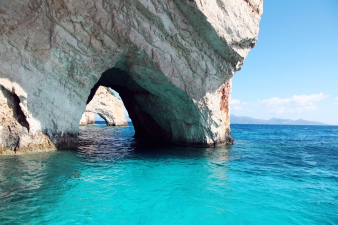
In the north of the Greek Ionian island of Zakynthos at an area called Skinari you will find the magnificent Blue Caves. The Blue Caves are one of the islands most famous natural attractions and were discovered in 1897 by Antonio Komouto. The caves attract thousands of visitors each year and are located just below the lighthouse at Cape Skinari. The caves owe there name to the blue waters inside them. Objects below the water appear to turn blue. This includes people who can enter the water inside the caves to swim.

Find more at Blue Caves44

Deepest lake in South America http://ow.

Deepest lake in South America http://ow.ly/vvQ7301At55

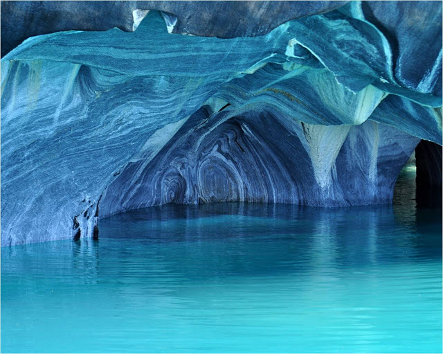
Shared by Argentina and Chile the deepest lake in South America is famous for its trout and salmon fishing. The waters of General Carrera Lake are beautiful, a glittering combination of emerald, turquoise, aquamarine and azure. The sky may be blue but the waters seem bluer still.

However along its banks, directly below the Andes, sheer marble cliffs present themselves to further astound the visitor.  Over the millennia they have been weathered and folded to create a stunning cathedral of marble.Laga General Carrera Lake 1